Introduction
Hadleyville cemetery is a small cemetery located on a country road in Eau Claire County. Just recently, Hadleyville lost all of their data associated with the cemetery. This means that graves and the people buried in them were not logged in a database anymore. The task at hand was to go to the cemetery, collect the data and map out each grave, and to create a GIS for the Hadleyville cemetery to replace the lost data. A GIS was created because instead of a simple map, a GIS is able to give a visualization of the cemetery as well as keep a database for all of the graves in the cemetery. The data was collected using a notebook. A drone was used to create the arial map of the cemetery and each grave was heads-up digitized into the map. The GIS will allow for the cemetery to keep organized records of each of the graves along with a map for visitors to use.
Study Area
Hadleyville cemetery is located on the Southern end of Eau Claire County. It is in the town of Eleva and is located on a country road. Figure 1 shows where the cemetery is located. The data was collected in early fall before the leaves began to turn.
 |
| Figure 1. Map of Hadleyville cemetery via Google Maps. |
Methods
In order to collect the data, groups went to the cemetery and collected each tombstone's data into a notebook. The original plan was to map out each grave using a survey grade GPS. Unfortunately, the GPS was to timely of a process and instead, each grave was heads-up digitized into the GIS. For the task at hand, a survey grade GPS would have been nice to use, but also may have been overkill. The accuracy of the drone image is high enough that heads-up digitizing is an ideal method when creating the GIS. The reason that data was recorded in a notebook is because technology is not always the most reliable source. As seen in the issue at hand, sometimes digital data can be lost for unknown reasons. A pen and paper is far more reliable for this sort of task.
Once all of the data and imagery was collected, the next task was to transfer the data into a digital medium that would allow for the creation of a GIS. The first step was to collaborate with each other and put all of the data into a single shared spreadsheet. Once all of the data was combined, the data was normalized. The class decided what the most important aspects of data were for each gravestone. The data that was kept was first and last name, middle initial, legibility, stone type, year of birth and death, if the stone was standing, the occupancy number, and any notes. The last step in the spreadsheet was to assign each grave an ID that would match up with the arial image. The last step was to put the spread sheet into ArcMap and use a table join to join the data to the digitized tombstones on the map. The results of these methods will be shown in the next section.
Results
Figure 2 shows part of the table once it was entered into ArcMap and joined to the tombstone feature class. Any spot in the table where there is a "Null" value is either a result of the tombstone not providing the data or the tombstone not being legible.
 |
| Figure 2. Table after data was joined to the tombstone feature class. |
The data from the table was joined to the tombstone feature class that was created. Figure 3 shows the final map of the graves and the arial image. Each grave is shown by a yellow triangle so that it is easily found.
 |
| Figure 3. The final map of the Hadleyville cemetery and each of the mapped out grave sites. |
The final map that is displayed above doesn't showcase the most important part of this GIS. Figure 4 below shows how each grave can be selected. Once selected, all of the recorded data will be displayed. This will allow people to find graves that they are looking for without having to walk all around the cemetery. Some graves have pictures to go with them.
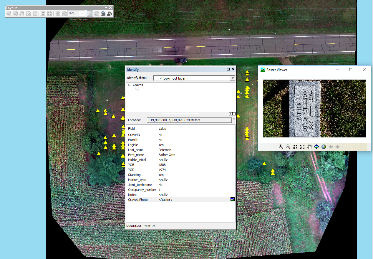 |
| Figure 4. Each grave can be selected and will show the data collected. |
Conclusion
Overall, the project went smoothly. Some things that would probably have sped up the process would be if each group was more vocal about what rows of graves they were going to collect data for. At first, bringing all of the data together was a slow and confusing process. Regardless, the project was still completed. For the most part, all of the groups collected data in similar ways, which made it easy to read other groups data. Unfortunately, there wasn't enough time to go back to the cemetery and double check that our collaborated data was put together correctly. If the opportunity presented itself, it would be best to take our combined spreadsheet out to the cemetery to check that each grave ID matched up with where it actually was placed. Overall, the survey was pretty successful. Beside missing some of the photos of graves, it seems like all of the data was collected. The good thing about the GIS that has been created, is that it can easily be updated and maintained by the city.
No comments:
Post a Comment